www.micahimages.com

An Guide to Independent Trekking In the
Himalayas is currently being redesigned and incorporated in to a new site.
For a sneak peak at the new site see
http://www.indietrekking.com
Himachal Pradeshi
Himachal Pradesh is another of India's major trekking destinations however there is none of the lodge infrastructure that exists in neighboring Uttarakhand so most treks are camping only. There are a few homestay trekking options in the Spiti Valley. I have done a few treks in Himachal but not as many as Ladakh or Uttarakhand in addition to the treks I've done I mention a few of the other popular treks in the state.
Himachal Pradesh Trekking Practicalities
Fortunately there is little regulation of trekking in Himachal and for the most part you are free to go where you wish. Exceptions are treks that pass through the areas close to the Chinese border. For these treks you will need an interline permit usually pretty easily obtained for free from the nearest major town. In the past there have been incidents of trekkers being attacked and robbed in the areas around Manali and the Pravati Valley and most guidebooks discourage independent trekking in those areas. I'm undecided as to whether this is justified or not. More than likely you would be fine but it is undeniable that there have been some incidents in the past so it is important to weigh the risks before heading out. But remember it always "feels" safe until something happens.
Trekking Routes
Pin-Parvati Pass The full classic route takes 7-10 days between the Parvati Valley near Manali and the Pin Valley in Spiti. I did a shorter version of this trek hiking up to the pass from Mud in the Pin Valley and then returning back the same way. Although much of the better scenery of this trek is probably on the Paravati Valley side approach to the pass, I was hesitant to do this full trek on my own due to the duration and the aforementioned security issues of trekking in the Paravati Valley. Hiking up to the pass is a nice short but strenuous hike from Mud. From Mud hike up the dirt road along the western side of the valley. Eventually you will reach a junction of three valleys continue down the western most valley on the northern side of the river. The trail is good and well marked until the point at which you need to cross the river. I camped on a grassy section near a spring just before the river bends to the north and is joined by another stream that flows from the Pin-Paravati Pass. At this point you need to either ford the river or continue to the north and cross over the glacier from where the river flows and then hike back from the other side of the river. On the other side of the river the trail is nearly nonexistent from what I could see. I ended up just reading the terrain and hiking up the easiest path I could. There are a series of grassy meadows and plateaus where it is possible to camp on the north side of the stream that heads up to the pass. I hiked up just before the terrain turned rough and camped a second night there. It was only about three to four hours of walking but the weather turned bad and I road out a snow storm that afternoon and night. There is little in the way of a path and after a fresh foot of snow pretty much no path. Just head up the snow field to the lower right of the large peak at the head of the valley. There are a few prayer flags marking the pass which is a long walk over the snow field. Its possible but long to return down from the pass to Mud in the same day.
|
Duration: |
full trek 7-10 days (up to the pass from Mud 2-4 days) |
|
Route Finding: |
Difficult |
|
Equipment needed: |
full camping gear and food for the duration of the trek |
|
Comments: |
The pass is high permanently snow bound and route finding over the pass is difficult so don't make this your first independent trek in the Himalayas. |
Kinnaur Kailash Parikrama Trek Foreigners need a permit for this trek obtainable in Rekong Peo from the tourist information center near the main bazaar. Technically you are required to have either a group of 4 or have a guide, I was able to persuade them to give me a permit individually by agreeing to write a statement that I accept responsibility for my own safety while trekking alone. This trek follows the portion of the traditional pilgrimages circuit (Parikrama) aournd the sacred Kinnaur Kailash peak although the peak itself is not visible from anywhere along the trek. The road goes to Lambar currently the village past Thangi which is reachable by bus from Peo. It looks to be a while before the road will be extended to Charang, and even when it is it will likely be closed quite a bit due to landslides. Despite what the Leoman series map says Charang is on the South bank of the river (Lousy Indian maps are the hardest part about trekking in the Indian Himalaya) so cross the river when the trail divides at a bridge before the ITBP check point. The trek from Lambar to the ITBP check point is not that great the route goes back and forth from the road under construction to the original trail and the views are nothing special. I left Lumbar at 1:00 pm and got to the ITBP checkpoint at 6:00 pm. After the checkpoint the trek gets nice. Charang village is a very scenic and friendly village where it is possible to stay. From Charang head up to the left (west) of the village any of the trails that head up should get you there. Aim for the high ridge on the right its not really a pass but more of a high traverse on the right slope of the ridge. The trail is good until Lalanti where it crosses the river then it becomes vague but is marked pretty regularly by carrins. There was a big snow storm about 5 days before I did the trek so a bit above Lalanti where the terrain becomes rocky it was also covered in snow. I camped just before the snow line near a spring. Starting from the checkpoint with an hour and a half stop in Charang and leaving at 9:00 am I got to that camp about 4:00 pm. The next day I started at 8:00 am and got to the base of the pass at 11:30 am. I pitched my tent on a snow covered ridge just opposite the steep section. No water but lots of snow which takes a surprisingly long time to melt even on a bright sunny day. A better place to camp is by the small pond a bit further back but I wanted to be as close to the pass as possible. The pass is very steep and when I climbed it covered in snow. I hiked the pass twice the first time that afternoon I made steps in the snow with my trekking pole and boots to the top of the pass. It took 2 hours from the base of where the pass gets steep to get to the top making foot holds. The next morning I packed up and hiked over the pass with all my stuff using the foot holds I made the previous afternoon, it took 1 hour to get to the top using my foot holds from the afternoon before and about 4 hours down to Chitkul from the top of the pass. I think the pass is maybe easier with snow on it since I prefer snow to loose scree which is the alternative. It is a very steep pass on both sides crampons would help if there has been a recent snowfall, but it’s possible with out, I didn’t have them. Chitkul is a great place as well. There are two buses a day from Chitkul back to Peo one in the morning and the other in the early afternoon.
|
Duration: |
3-5 days |
|
Route Finding: |
Moderate, trail gets vague in the upper valley but just head straight down the valley to the |
|
Equipment needed: |
full camping gear and food for at least two days |
|
Comments: |
The pass if pretty difficult in any conditions either you will have to deal with steep snow or steep loose scree on both sides of the pass. |
|
Pictures and Journal Entry from the Kinaur Kailash Parikrama Trek |
|
Kibber (Spiti Valley) to Tso Moriri This trek is much easier the other direction from Tso Moriri to Spitti both physically and logistically. For details see Tso Moriri to Spiti on the Ladakh page.
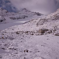
Approach to the Pin-Parvati Pass from the Pin Valley side (the pass is to the right of the center peak behind the ridge).
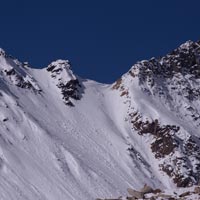
Steep approach to the Charang La, Kinnaur Kailash Paarikrama Trek
View from the Charang La, Kinnaur Kailash Paarikrama Trek
An Overview of other Trekking Possibilities in Himachal Pradesh
Trekking Routes:
Indrahar Pass This short trek is probably the most popular trek from Mcleodganj, near Dharamsala. To go to the Pass and back takes about 3-4 days. It may be possible to do this trek without a tent making use of the rest house at Triund 10 km from Mcleodganj and doing a long day trek to the 4316 m Indrahar pass. It is also possible to continue over the pass to Kharamukh (5-6 days).
Kibber to Ki Gompa to Spiti Valley view point This is a very nice day hike form Kibber. Hike down the road or get a ride to Ki Gompa then hike up the steep trail that heads up the side of the valley just east of the Gompa. At the top of the ridge you will reach a small village head east down a dirt road under construction to a small pass or saddle. From the Saddle head south up the ridge which over looks the valley from the top there are impressive views over the entire Spiti Valley and down towards Kaza. Retrace you steps down to the village and then head along the dirt road northwest back towards Kibber. For pictures and journal entry of this trek click here.
Kaza to Dhankar Gompa I've heard its possible to trek between Kaza and Dhankar Gompa via the high plateau to the north of the valley staying at homestays in the villages along the way but I do not know the details. It should take about 2-4 days.
Pin Valley to Kinnaur This trek links the Pin Valley to Kinnaur taking about 5-7 days to complete and requires camping equipment and food. An interline permit is also required which you can get easily in Kaza free of charge.
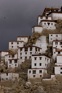
Ki Gompa Spiti Valley