www.micahimages.com

An Guide to Independent Trekking In the
Himalayas is currently being redesigned and incorporated in to a new site.
For a sneak peak at the new site see
http://www.indietrekking.com
Uttarakhand (Uttaranchal) (Pilgrim Treks, Lodge Treks, Camping Treks)
Uttarakhand formerly known as Uttaranchal is another place in the Indian Himalaya where it is fairly easy to trek on your own. The Himalaya in Uttarakhand falls into two regions, Garhwal and Kumaun. As the source of India's most sacred rivers including the Ganga, Garhwal has been a pilgrimage destination for centuries. The flow of pilgrims into the region meant that a significant amount of roads and other infrastructure was built high into the mountains to service the pilgrims. For the trekker this means that one can hike into a very high alpine environment in Garhwal on relatively short treks.
Uttarkhand Trekking Practicalities
While in many areas of Uttarkhand you are free to trek as you like, there are some annoying regulations governing trekking in some regions of Uttarakhand. The number of people per day allowed to trek above Gangotri to Gaumukh, the source of the Ganges, as well as further up to Tapovan is restricted. This is a good thing to take pressure off the region, unfortunately there is also a two tier pricing for the permit where foreigners pay significantly more than Indians (I'm waiting for the day when India realizes it doesn't have to stoop to the level of Nepal and African countries such as Kenya and Tanzina which have no other source of income except to extract as much money as they can from tourist of so called rich countries, China got rid of official dual pricing years ago. So the question is does India aspire to be more like Nepal and Kenya or China, South Korea, and Japan. If you go by their tourism pricing structure they appear to be lumping themselves in with Nepal and Kenya). The permit can be obtained in Uttarkashi on the way to Gangotri. The office is on the road to Gangotri 2 to 3 km outside of town. Ask locally for specific directions. The Har Ki Dun valley, as well as the Valley of Flowers are also both National Parks and require a dual priced entry fee to visit. Trekking above Joshimath to the Kuari Pass requires a permit as well. This would not be that big a deal if the Forest Department would issue permits to trekkers unfortunately they require guides and only issue the permits through travel agents, despite the fact that a blind man would have a hard time getting lost on the way to the Kuari pass making a guide completely unnecessary. As a result the independent trekker has two options hike around the check point at the top of the ropeway above Auli or pay a travel agent to put them on a permit for an inflated price. Trekking inside the Nanda Devi Sanctuary is completely prohibited. Some treks near border areas require interline permits.
Trekking Routes The Char Dham consists of four temples near the sources of the four main tributaries that merge to form the Ganges (Ganga). Two of the temples Yamunotri and Kedarnath require a walk (or short trek) to reach them, while the other temples at Gangortri and Badrinath can be reached by road and are the starting points for treks further into the mountains.
Yamunotri: This temple marks the source of the holy Yamuna river which eventually joins the Ganga at Allahabad. The temple is a 5 km walk along a wide good path from Janki Chatti, opposite the pretty village of Kharsali which is well worth a visit. There are a number of lodges to serve the pilgrims at Yamunotri so it is possible to stay there as well as Janki Chatti. Further hikes from Yamunotri can be done as long day hikes or camping hikes. A very steep trail leads up to the glacial lake above Yamunortri which is the true source of the Yamuna river. I did not make it all the way to the lake but this can probably be done in a long day hike from Yamunotri for the fit and acclimatized or more comfortably in two days for those equipped to spend a night out. I was told it takes about 5 hours to get to the lake. Another option is to climb up to Ball pass which links Yamunotri with the Har Ki Dun Valley. To go to Har Ki Dun you will need to spend at least one or two nights out before reaching the rest houses that line the Hari Ki Dun Valley. Allegedly the top of the pas is only 7 km from Yamunotri so it should be possible to reach the top of the pass as a day trip from Yamunotri although it would be a large elevation gain from 3185 m Yamunotri to the top of the 4880 m pass. I attempted this but was unable to find the correct path even after asking several locals. I ended up walking a couple hours up a trail that ended in nothing across the river from the temple. I suspect the path joins the path to Yamunotri slightly before Yamunotri where there is a clear junction but I did not have time to test my theory.
|
Duration: |
1-2 days |
|
Route Finding: |
Trail to Yamunotri is very easy to follow, paths from Yamunotri to other destinations are more difficult |
|
Equipment needed: |
none for Yamunotri, ample lodges and small restaurants are available at Yamunotri, for further treks camping gear and supplies for a few nights are required |
|
Comments: |
The area around Yamunotri is nice but I would judge it to be less scenic than the other Char Darm locals in terms of high mountain views. I will say that I explored the area less thoroughly than the regions around the other temples, the views from the lake and the top of the pass may be very impressive. The village of Kharsali near Janki Chatti is one of the highlights of the area and should not be missed. |
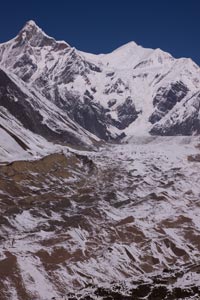
Gangotri: Gangotri is the jumping off point for the trek to Gaumukh (the source of the Ganges) and the beautiful meadow of Tapovan which sits above it. You will need to get a permit for this trek in advance from the Forest Department office in Uttarkashi. There is a quota system so you may have to wait a few days to make the trek if its busy. There is another very good trek from Gangotri to the lake of Kedar Tal. A beautiful lake surrounded by a bowl of white mountains adjacent to a glacier. Fortunately you don't need a permit for this trek so if you have time to kill why you wait to do the Gaumukh trek you can trek to Kedar Tal in the meantime. The trail starts on the other side of the river from the main town and temple of Gangotri and climbs steeply following the the tributary that joins the Ganges at Gangotri. Its a 46 km round trip to the lake. For the fit and acclimatized its possible to do in a very long day trip but the route is steep and it would be much more comfortable to do in 2 days, but you will need a tent or some sort of shelter for this as there is nothing en route.
|
Duration: |
1-3 days |
|
Route Finding: |
Easy until Gaumukh, route finding across the glacier to Tapovan can be tricky, for Kedar Tal the trail is very straight forward with no junctions until the end where the trail becomes less distinct crossing the terminal moraine of the glacier before reaching Kedar Tal. |
|
Equipment needed: |
sleeping bag is useful, there are lodges at Bhojbasa 5 km from Gaumukh (14 km from Gangotri), at Tapovan it may be possible to sleep in on of the Sadhu's simple rock walled ashrams but you can't count on it, so if you don't have a tent leave enough time so that you can return to Bhojbasa if necessary, if you do Kedar Tal in more than one day shelter will be required |
|
Comments: |
Its possible to hike to Gaumukh and back in a day from Gangotri for those short on time, but its more pleasant to take two or three days and add a trip up to Tapovan. Both Tapovan and Kedar Tal are very beautiful alpine areas with fantastic views of high peaks. |
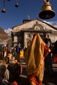
Kedarnath The setting of the temple at Kedarnath is the most impressive of any of the Char Dham temples. Its backed by a white wall of rock and ice. From the end of the road at Gaurikund, its a 14 km hike along a very wide and obvious pilgrim trail. There is plenty accommodation available from pilgrim lodges at Kedarnath and food is available both at Kedarnath and from stalls along the trail. Its possible to hike up to Kedarnath in a long day hike from Gaurikund but its much better to spend at least one night and use Kedarnath as a base to hike up further into the mountains. There are two lakes within day hiking range, Gandhi Sarovar (a relatively short hike up to a glacial lake north of Kedarnath where some of Gandhi's ashes were scattered), and Vasuki Tal (a longer hike to hike to a lake over the eastern ridge).
|
Duration: |
1-3 days |
|
Route Finding: |
Easy |
|
Equipment needed: |
sleeping bag is useful but not really necessary, numerous lodges and ashrams at Kedarnath |
|
Comments: |
Its not a solitary wilderness experience but the throngs of pilgrims and spectacular peaks make Kedarnath a great place witness "India" and the great Himalayas. |
Badrinath, Hem Kund, and the Valley of Flowers Badrinath is reachable by road but the region around it offers some great trekking. For Hem Kund and the Valley of Flowers start from Govindghat on the road to Badrinath. I have not this trek myself as when I was in the region late October the lodges at Ghangaria (13 km from Govindghat) were closed for the season. Ghangaria is a base to make day treks into the Valley of Flowers (national park entry fee required) and to the sacred Hem Kund an important pilgrimage place for Sikhs. There are a few very nice day hikes that can be done from Badrinath. A hike along the oposite side of the river as the road up to Mana village is a nice walk but its better to continue up the valley to the east of Mana to reach Vasudhara Falls (about 5 km from Mana). Another nice walk is to Nilkantha base camp directly east of Badrinath.
|
Duration: |
1-4 days |
|
Route Finding: |
Easy |
|
Equipment needed: |
sleeping bag is useful but not really necessary (for Hem Kund/Valley of the Flowers) |
|
Comments: |
With time and gear it may possible to head further up the beautiful glacial valley which contains Vasudhara Falls. |
Temple at Kedarnath
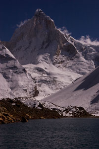
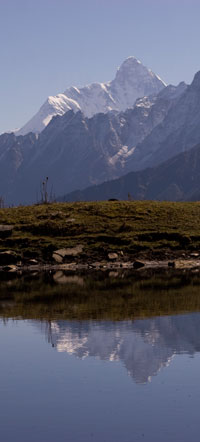
Kedar Tal, near Gangortri
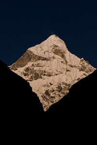
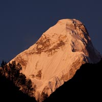
Nilkantha from Badrinath
Trekking Routes Uttarakhand has more trekking lodges than any other state in India, still only a few tails can be done in this way.
Pindari Glacier This is a nice short trek at the southern end of the Nanda Devi Sanctuary that can be done very easily independently, requires no camping gear, and will get you up into some high Himalayan scenery but without any particularly high passes. Its pretty much an ideal trek for those on a low budget with limited time but still want a taste of Himalayan trekking. There are lodges throughout the trek (generally the government ones offer the best value). Near the tip of the Pindari Glacier known as "zero point" a locally famous Sadhu lives who goes by the generic name of Baba Gee. It is possible to stay with the friendly baba although your own sleeping bag is highly recommended.
|
Duration: |
5-7 days |
|
Route Finding: |
Easy |
|
Equipment needed: |
sleeping bag mainly if you are planning to sleep for a night near zero point at Baba Gee's ashram again you could get by without one but it is more comfortable with one. |
|
Comments: |
Its worth hiking up the ridge above Dhakri Khal especially early in the morning around sunrise. A nice side trip off the main Pindari Glacier trail is Kafni Glacier this side trip can be done in a day and does not require a tent unlike Sunderdhunga Glacier the other side trip off the Pindari Glacier trail. |
Har Ki Dun The Har Ki Dun is another well established trekking route there are lodges throughout the valley. I have not done this trek personally but it is supposed to be a straight forward lodge trek. Destinations further up the valley such as hiking over a high pass to either Yamunotri to the east or Kinnaur to the west will require camping equipment and supplies.
|
Duration: |
5-7 days |
|
Route Finding: |
Relatively easy from what I know, but no first hand experience |
|
Equipment needed: |
sleeping bag, tent and food if you are continuing over a pass |
|
Comments: |
I haven't done this trek personally. |
|
|
|
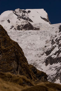
Milam Glacier & Nanda Devi East Base Camp This is a nice trek that offers very good views of Nanda Devi. A permit is needed from the SDM office in Munsiary but it is easy to obtain, even for foreigners, and free of charge just requiring a bit of leg work to make copies and drop off a copy of the permit at he ITBP post across town. There are no passes and the elevations are relatively low by Himalayan standards only a little over 4000 m. This trek is probably best done before the monsoon in May-June but I did it in early mid October finishing October 14th. Weather wise it was a great time to trek but it was just about as late as you could do it still relying on the small hotels for food and shelter. When I was going up all of the hotels along the trek were open but when I was going down a number of them had closed. The first part of the trek passes through a gorge with the high mountain views only opening up after Rikot. Of the villages of the upper valley Martoli probably has the best location. Its slightly off the main path take the path up to the left after Rikot and near where the abandon village of Tola sits on the opposite side of the valley. From Martoli you can hike up the slopes above the temple (30-45 minutes) to get a view of both Nanda Devi peaks, Trisul, and Hardeel (four +7000 m peaks). A route to the traditional Nanda Devi East base camp starts from Martoli but you will need at least 2 days of food to do this. Apparently there are some stone shelters you could use if not carrying a tent I did not personally make it up that direction. I went up to the base of Nanda Devi via the Pachu valley. From Pachu I made it up to the base camp in 3 hours but this is relatively fast still it can be done as a day hike. There is a nice camp site one and a half to two hours up the southern side of the valley and a rock shelter a bit further up from the camp site. There are trails on both sides of the valley but the one on southern side is better maintained and has better views of Nanda Devi. Milam is on the opposite side of the river as Pachu unfortunately as of October 2009 the northern most bridge across the Gori Ganga is at Burphu about 1.5 to 2 hours back down the valley from Pachu. If you don't mind the cold and if the river is not too high apparently there is a place just below Milam where it is possible to ford. The ITBP camp at Milam can be a bit annoyingly over zealous but friendly. If they try to compound your camera for your stay in Milam just argue a lot and offer to show you digital pictures when you leave to assure them you didn't take any pictures of the camp (they didn't even bother to check mine when I left), if you have a film camera don't tell them you have a camera. The view from Milam Glacier "zero point" itself is not that great lots of grey rock grey ice and grey water. The approach is better, but for the best view hike up the east side of the valley for about an hour and a half to two hours past "zero point" where you will get a panoramic view of the peaks and see the glacier descending from the slopes of Trisul. The trail is quite good after initially being rather rough. The trail starts where the stream comes down to the glacier from the east near zero point. Cross to the northern side of the stream and climb the steep slope the trail eventually levels off and traverses along the eastern side of the valley high above the glacier.
|
Duration: |
5-10 days |
|
Route Finding: |
Easy, broad well maintained path |
|
Equipment needed: |
sleeping bag, a sleeping mat is useful since most places do not have mattresses, tent and food if out of season (after mid October) |
|
Comments: |
If you do this trek in October/November you could still get by with out a tent as there are many abandon houses in which you could sleep but you would need a very good sleeping bag. The main issue would be bringing enough food. If you only have time for either Pachu or Milam I would probably recommend Pachu especially if you only go to zero point at Milam but if you hike up above zero point the two become more comparable. It is still very cheap to trek here with sleeping costing between 25-100 rupees, a thali 30-50 rupees, and a cup of tea for 5 rupees. The accommodation is basic but fine. |
Kafni Glacier, Pindari Glacier Trek
View from above Milam Glacier, Milam Glacier Trek
Nanda Devi East from Pachu, Milam Glacier Trek
Trekking Routes If you have your own camping gear the number of possible routes throughout Garhwal and Kumaun are almost endless. I'll just mention the two short treks I did.
Roop Kund This is a nice short trek that can be done independently in the "local style" (there are numerous roofless rock shelters along the way) or full camping. The trek finishes at the mysterious lake of Roop Kund which contains a large number of human bones. However it is worth hiking up to Jyuri Guli, the pass above the lake for incredible views of the towering 7120 m (23,350 ft) face of Trisul, on the western edge of the Nada Devi Sanctuary. The trail heads up to the right (south) side of the lake.
|
Duration: |
3-4 days from Wan |
|
Route Finding: |
Easy most difficult part is finding your way through the sprawling village of Wan but fortunately there are many people to ask. |
|
Equipment needed: |
sleeping bag, food for at least 3 days, and shelter. |
|
Comments: |
Basic accommodation is available at Wan. From Wan to Bedni Bugyal is a short days walk. The main problem with Bhugu Basa the rocky campsite littered with stone shelters is a lack of water. Be sure to being lots with you from the great tasting spring at Bedni Bugyal. There is a stream but it is a long hour return hike away. Its possible to hike up to Roop Kund and Jyuri Guli from Bhugu Basa and return to Wan in the same day. |
Kuari Pass While this trek does not really go up into the high mountains it follows a ridge just opposite the Nanda Devi Sanctuary which offers amazing views of the mountains, including some of the best views of Nada Devi. Unfortunately the powers that be in Joshimath no doubt lobbied by the travel agents have made it this classic and beautiful trek difficult to "legally" do on your own. A permit is required that will only be issued through travel agents and not to individual trekkers without guides. I paid a travel agent to put me on a permit with a group that was going then after the check point at the ropeway above Auli I went off on my own. Another possibility would be to hike around the check point through the forest on either side then rejoin the trail. No one will check your permit any where else along the trail. There are few options for this trek, you can go out and back from Joshimath (2-3 days), you can return back down to Tapovan (2-3 days), or continue over the pass to and exit via Ghat or Wan (5-10 days).
|
Duration: |
2-3 days heading up to the pass and back down (5-10 days continuing over the pass) |
|
Route Finding: |
Easy, though Gurson Bugyal the trail becomes indistinct and splits many times but just head towards the east around the hill and you will eventually wind up on the main trail. |
|
Equipment needed: |
sleeping bag, tent, at least 2 days of food |
|
Comments: |
From Kuari pass a nice day hike is up to the relatively small 5183 m (17,000 ft) peak of Pangerchuli. Despite relatively low height the views from the top are impressive with panoramic views including the peaks of the Nada Devi Sanctuary. There is no path to the peak head over the ridge from the meadow below the pass and follow ridgelines up to the base of the mountain. Then its a climb over boulder sized scree to the summit. The meadow below the Kuari pass can be reached in a day from Auli but there are many beautiful campsites along the way if you want to take your time. |
Nanda Devi from Kuari Pass Trek