www.micahimages.com

An Guide to Independent Trekking In the
Himalayas is currently being redesigned and incorporated in to a new site.
For a sneak peak at the new site see
http://www.indietrekking.com
Nepal (Everest Region, Annapurna Region, Langtang Region)
Nepal is perhaps the premier trekking destination in the world and no where is the trekking industry more developed than in Nepal. While this means more trekkers it also means that Nepal is the easiest place in the Himalayas to trek independently. Anyone can do it even if you've never hiked anywhere. Good maps and trekking guidebooks are available in the many bookstores of Kathmandu and Pokhara. On the most popular routes it would be nearly impossible to get lost. Tea Houses and Lodges are spaced so frequently along the main trekking routes in the Everest, Annapurna, and Langtang regions that you can walk for as long as you like and when you are tired or hungry there is rarely a time when a lodge is not within an hour or two's walk. If you don't like the "trekking highway" feel there are numerous minor trails and side trips in these regions so that in some cases you can hike all day without seeing a soul and then arrive in the evening at a lodge to meet up with fellow trekkers for some pleasant conversation over a hot meal or cup of tea. Where else in the world can you hike for more than a month in a remote mountainous and road-less area carrying little more than a day pack on as little as $10 to $15 a day. Below are an overview of the main "tea house" trekking routes in Nepal. This is intended just to help you decide where to go I did not include detailed information since there is plenty of information out there on how to do these treks independently.
Nepal Trekking Practicalities
To trek legally in Nepal you will need a TIMS (Trekkers Information Management System) card before you go on your trek. As of March 2010 these are no longer free. Nepal seems to be trying to further discourage individual trekking as the list of places that don't require guides and special permits has been shrinking over the years and now the new TIMS fee structure also socks it to the independent trekker. Individual trekkers must now pay a steep $20 (Groups through agents pay $10). TIMS cards are obtained from the new tourism complex just south of Ratna Park bus stand. Its a 20-30 minute walk from Thamel or you can go to any major street in Kathmandu and likely find a micro (minivan) that is heading to Ratna Park. This is also where you can find the offices to get the National Park Entry permits (1000 Nepali rupees) and Conservation Area entry permits (2000 Nepali rupees) they are no longer in the building on the east side of Thamel. For Annapurna you must get a Conservation Area permit before leaving for your trek. For Langtang and Everest you can buy your National Park entry permit when you enter the park, or ahead of time in Kathmandu if you feel like it.
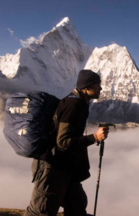
Trekking Routes If you want to see high alpine scenery and big white mountains head to the Everest Region.
Lukla to Everest Base Camp: One of the most popular routes in Nepal if any trek has the "trekking highway" feel to it, its this one. Since most people go out and back along the same trail you will be running into people constantly during the high trekking seasons of Fall and Spring. It is the quickest route to get to Everest Base camp and to catch a glimpse of the highest peak in the world from Kala Pattar (you can not see Mt. Everest from the Nepal Base Camp).
|
Duration: |
10-14 days |
|
Route Finding: |
Easy, just follow the crowd. |
|
Equipment needed: |
sleeping bag is useful, lodges/tea houses throughout the trek |
|
Comments: |
On its own its not the best trek, the view from Kala Pattar is good, if you have limited time and want to see Everest Base Camp its the only option, but if you can spare some more time its much better when combined with the other valleys of the region. |
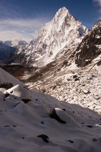
Gokyo Valley: Probably the second most popular route in the region, but deservedly popular. The Gokyo Valley is beautiful strewn with lakes all the way up the valley until the Tibetan border and the mighty 8201 m Cho Oyo. The valley also has some of the best views of Mt. Everest in Nepal. The view from "Knobby View" between the 5th and 6th lakes is one of the best trekking view points in the Himalayas.
|
Duration: |
10-14 days from Lukla or an additional 4-6 days added on to the Base Camp trek |
|
Route Finding: |
Easy, can be a little tricky crossing the Cho La from the Base Camp Valley to the Gokyo Valley |
|
Equipment needed: |
sleeping bag is useful, lodges/tea houses throughout the trek |
|
Comments: |
Combining this trek with the Base Camp trek via the Cho La (5420m/17,782 ft) pass is a popular option and for a few extra days makes the trek much more impressive. There are a number of day hikes that can be done from Gokyo so don't just pass through stay a few days and explore the upper Gokyo Valley. |
Chukhung Valley: This valley holds Island Peak one of the most popular trekking peaks in Nepal. The scenery around Chukhung is stunning and while there are no views of Mt. Everest, the beautiful Ama Dablam dominates the skyline. There are several day hikes that can be done from Chukhung including hiking up the viewpoints of Chukhung Ri (5559m/18,238 ft) and Chukhung Tse (5857m/19,216 ft). The Kongma La (5535m/ 18,159 ft) between Chukhung and the Lobuche in the Everest Camp Valley is one of the most beautiful in the region.
|
Duration: |
9-13 days from Lukla or an additional 2-4 days added on to the Base Camp trek |
|
Route Finding: |
Easy |
|
Equipment needed: |
sleeping bag is useful, lodges/tea houses throughout the trek |
|
Comments: |
Combining this trek with the Base Camp trek via the Kongma La is a great option and even better to continue on to Gokyo Valley from there. I didn't see anyone for the six hours I hiked over this pass, just pristine mountain scenery. Its a strenuous pass but well worth the effort and not too tricky once you pick up the path from Chukhung. |
Bhote Valley: This is the western most valley that it is possible to Tea House trek in. From Gokyo, pass over the Renjo La (5417m/17,772 ft) with great views of Mt. Everest to reach the Bhote Valley. There is a Tea House/Lodge between Gokyo and Thame now despite what many books say, although it is possible to make it from Gokyo to Thame in a day. However, to explore the upper Bhote Valley you will need a tent.
|
Duration: |
An additional 1-2 days added on to the Gokyo Valley trek |
|
Route Finding: |
Easy |
|
Equipment needed: |
sleeping bag is useful, lodges/tea houses available but less frequently than the other valleys, a tent if you would like to explore the upper Bhote Valley. |
|
Comments: |
Combining this trek with the Gokyo trek via the Renjo La makes for a great and seldom used route back to Namche Bazaar. It is the least visited of the four valleys but strikingly beautiful and a great place to escape the crowds. |
|
Pictures and Journal Entry from the Bhote Valley and the Renjo La. |
|
Jiri to Namche Bazaar: This is the most popular route to walk into the Everest Region, that said it is much less popular than the fly in approach so that even in the high season you will likely only run into a handful of trekkers per day. It is a very strenuous approach despite not reaching the high altitudes found above Namche due to the numerous passes. While the views are not stunning it does give the trekker a taste of the middle hills and the villages are culturally more interesting than the "lodge towns" further up.
|
Duration: |
5-7 days from Jiri to Namche Bazaar |
|
Route Finding: |
Easy |
|
Equipment needed: |
sleeping bag is useful, lodges/tea houses available throughout the trek |
|
Comments: |
If you have the time its a satisfying way to enter/exit the region. Personally, if I had to choose between the Jiri to Namche stretch and any of the valleys mentioned above I would skip the Jiri to Namche and spend more time in the upper valleys. |
|
Pictures and Journal Entry from Jiri to Namache |
|
Arun Valley: This is another way to walk in/out of the Everest Region. I have not personally done this route but I include it here along with what I have heard about it. Less used by tourist but more heavily used by locals its probably the most culturally interesting of the trekking routes in the region. The main draw back is that it finishes in far eastern Nepal and a very long bus ride from Kathmandu. It is also a little longer than the Jiri route.
|
Duration: |
6-9 days to Namche Bazaar |
|
Route Finding: |
Moderate |
|
Equipment needed: |
sleeping bag is useful, lodges/tea houses available throughout the trek but more basic typically catering to locals rather than tourists |
|
Comments: |
Like I said I have not personally done this route but it is likely very interesting since so few people hike this way. |
Trekking to the Kongma La with Ama Dablam in the background, Everest Region, Nepal
View while crossing the Cho La to the Gokyo Valley, Everest Region, Nepal
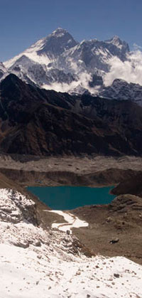
View of Everest and Gokyo Valley from the Renjo La to the Bhote Valley, Everest Region, Nepal
Trekking Routes The Annapurna region is the most diverse of the trekking regions in wide variety of landscapes and views as well as cultural sites such as monasteries and villages. Unfortunately the classic Annapurna circuit trek is being ruined with a road which is closet to completion along the Jomsom side of the circuit.
Annapurna Circuit (Around Annapurna): Along with the Everest Base Camp trek it is probably the most well known trekking route in Nepal. The Manag side of the trek is amazing and still retains its classic feel. Since everyone goes the same way (counterclockwise) because the Thorung La is much easier form the Manang side than the Jomsom side it is easy to space yourself out and feel like you are trekking alone despite the treks popularity. On the Jomsom side things are not so rosy. Flown in Jeeps ply the road between Jomsom and Muktinath many more trekkers are encountered in both direction from the added people who are trekking the "Jomsom" trek (not worth the time in my opinion as it takes you through the least interesting part of the Annapurna Circuit). Still the Jomsom side has a number of great villages and some of the most comfortable accommodation in the Himalayas.
|
Duration: |
14-20 days |
|
Route Finding: |
Easy |
|
Equipment needed: |
sleeping bag is useful, lodges/tea houses throughout the trek many even with free solar hot showers |
|
Comments: |
Even with the road its still a classic trek. The Manang side of the trek is over the Thorung La is fabulous trekking, and without a doubt the highlight of the trek. The Jomsom side has the feeling a "ski out" (the shallow slope where you are just trying to make it back to the lift). Still with places like pilgrim town of Muktinath, Kagbeni, and the hot springs at Tatopani it is a relaxing way down where you can even find many locally distilled brandies including apricot, apple, and cherry. |
Tilicho Lake: This is a spectacular and very worthwhile side trip from the Annapurna Circuit. This lake sits at just under 5000 m and is surrounded by snow covered peaks.
|
Duration: |
2-3 days added to the Annapurna Circuit trek |
|
Route Finding: |
Easy (once you get on the right trail) there was an old trail no longer in use that fooled us, ask in Manang to make sure. |
|
Equipment needed: |
sleeping bag is useful, lodges/tea houses at Tilicho Base Camp |
|
Comments: |
Unless you are really short on time, or suffering from AMS in Manang, there is no reason you shouldn't include this side trip on the Annapurna Circuit. |
Annapurna Sanctuary (Annapurna Base Camp): The spectacular view from Annapurna Base Camp a bowl surrounded by high white peaks in every direction makes this trek. This trek can be done on its own or tacked on to the end of the Annapurna Circuit trek. The view from Poon Hill (which is good but not as good as Sarangkot near Pokhara) can also be added to this trek.
|
Duration: |
6-7 days on its own, with Poon Hill 9 days, and 5 to 6 days added to the Annapurna Circuit trek |
|
Route Finding: |
Easy but a few tricky junctions (fortunately there is usually no shortage of people to ask) |
|
Equipment needed: |
sleeping bag is useful, lodges/tea houses throughout the trek |
|
Comments: |
Basically the view from Annapurana Base Camp is what this trek is all about the the rest is just a prelude and a postlude. But what a view it is. |
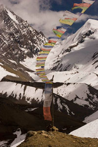
Prayer flags at "High Camp" before the Thorung La, Annapurna Region, Nepal
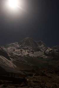
Full moon at Annapurna Base Camp, Annapurna Region, Nepal
Trekking Routes The Langtang region is less well known than the more famous Everest and Annapurna regions but it offers some of the best short trekking routes in Nepal. Its the fastest way to get up into high altitude scenery, in addition there are many lower altitude trekking routes between the villages in the area. I have not explored this region as thoroughly as the other two regions with only a quick week long trek up into the Langtang Valley but what I have seen of the region impressed me.
Langtang Valley: The route up into the Langtang valley is relatively short and crosses no high passes. It is possible to go from Kathmandu up to 4000 m high altitude scenery in as little as two and a half days. Although if you are not previously acclimatized it would be wise to take it slower than that. Using Kyangjin Gompa as a base it is possible to do numerous day hikes throughout the valley reaching altitudes in excess of 5000 m. If you have a tent and a bit of food your options are even greater. I would rate this as the best short trek in Nepal.
|
Duration: |
4-8 days |
|
Route Finding: |
Easy |
|
Equipment needed: |
sleeping bag is useful, lodges/tea houses throughout the trek |
|
Comments: |
Nice day hikes include the 5000 m hill behind Kyangjin Gompa, also cross the bridge south of Kyangjin and take the path that heads up to the Gangja La pass. Unfortunately the pass was snow bound when I was there but you can loop around and decend down a ridge further up the valley. It is a beautiful hike through forests meadows and with great views across the valley at 7227 m Langtang Lirung. You can also hike up to the upper Langtang Valley and the Langtang Glacier. Opportunities for exploration are almost endless. Update: I returned to the Langtang region in spring 2010. As of fall 2009 apparently many of the locations along the trail at the cohesion of the large lodge owners had formed "committees" to standardize room rates and food. While before there had been standardized menus but you could often work out deals for free rooms and discounted food with smaller lodges. Now it seems with threats of physical violence as well as property damage by the "committees" against lodge owners who break this seems no longer possible for rooms. It seems to have hurt the small lodges who can not compete when all prices are equal. Only four of the 22 lodges in Langtang village were open in April a high tourist season forcing all the tourists in to a few lodges. Fortunately I managed to secure a homestay with a family in the old village a much better experience. You can try striking up conversations with villagers to explore these opportunities. I talked with other individual trekkers who complained they got stuck in one of the few open lodges with big organized trekking groups and were therefore low priority for the lodge. I would say the best option is to stay at places in between the main places. Avoid Lama Hotel (the traditional first night stop) where the lodges charge an outrageous 400 rupees for a double, considering Kyangjin Gompa was only charging 300 and Lama Hotel is less than a days walk from the road. Riverside an hour after Lama Hotel, or Rimpoche before are good alternative places to stay. Also I would either avoid Langtang village or talk your way into a homestay it was very depressing there this time around with so many closed lodges. Kyangin you really have no choice but to stay there, and the surrounding area is beautiful. Its still a very nice hike but the "committee" thing has ruined some places, we'll see how long they can keep up the enforcement. |
Other Routes: There are numerous other routes which can be explored around the Langtang region. Most of them lower altitude routes between villages. But there is also the route past the pilgrimage lake of Gosain Kund which is a very popular option to link with the Langtang Valley and the route over the Gangja La pass. The Gangja La is often snow bound so inquire before setting out. The Tamang Heritage trial also gets good reviews from those looking for a less trekked area with more natural villages though it does not possess the same high mountain views as the Langtang trek.
|
Duration: |
Anywhere from an additional 2 days to 2 weeks. |
|
Route Finding: |
Relatively easy there are plenty of criss-crossing trails but just ask in villages and lodges and bring a map. |
|
Equipment needed: |
sleeping bag is useful, lodges/tea houses throughout the region and in any village |
|
Comments: |
I have not done these personally but there is a lot of trails in the area to be explored and many would have very few other trekkers on them if you are looking to get away from the crowds. |
|
|
|
Langtang Valley, Langtang Region, Nepal